


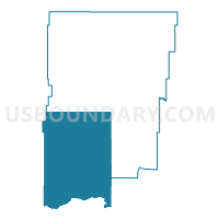
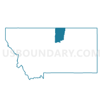
Precinct 17, Blaine County, Montana
About
Outline

Summary
| Unique Area Identifier | 611827 |
| Name | Precinct 17 |
| County | Blaine County |
| State | Montana |
| Area (square miles) | 1,207.94 |
| Land Area (square miles) | 1,203.13 |
| Water Area (square miles) | 4.81 |
| % of Land Area | 99.60 |
| % of Water Area | 0.40 |
| Latitude of the Internal Point | 48.06889560 |
| Longtitude of the Internal Point | -109.25550430 |
Maps

Graphs
Select a template below for downloading or customizing gragh for Precinct 17, Blaine County, Montana


Neighbors
Neighoring Voting District (by Name) Neighboring Voting District on the Map
Top 10 Neighboring County Subdivision (by Population) Neighboring County Subdivision on the Map
- Havre CCD, Hill County, MT (12,004)
- Fort Belknap CCD, Blaine County, MT (2,728)
- Big Sandy CCD, Chouteau County, MT (2,513)
- Chinook CCD, Blaine County, MT (2,410)
- Winifred CCD, Fergus County, MT (398)
- South Phillips CCD, Phillips County, MT (189)
Top 10 Neighboring Elementary School District (by Population) Neighboring Elementary School District on the Map
- Havre Elementary School District, MT (12,252)
- Harlem Elementary School District, MT (2,405)
- Big Sandy Elementary School District, MT (1,166)
- Bear Paw Elementary School District, MT (137)
- Cleveland Elementary School District, MT (81)
- Davey Elementary School District, MT (62)
- Landusky Elementary School District, MT (44)
- Warrick Elementary School District, MT (28)
Top 10 Neighboring Secondary School District (by Population) Neighboring Secondary School District on the Map
- Havre High School District, MT (12,655)
- Harlem High School District, MT (2,533)
- Big Sandy High School District, MT (2,415)
- Chinook High School District, MT (2,333)
- Dodson High School District, MT (350)
Top 10 Neighboring Unified School District (by Population) Neighboring Unified School District on the Map
Top 10 Neighboring State Legislative District Lower Chamber (by Population) Neighboring State Legislative District Lower Chamber on the Map
Top 10 Neighboring State Legislative District Upper Chamber (by Population) Neighboring State Legislative District Upper Chamber on the Map
Top 10 Neighboring 111th Congressional District (by Population) Neighboring 111th Congressional District on the Map
Top 10 Neighboring Census Tract (by Population) Neighboring Census Tract on the Map
- Census Tract 301, Fergus County, MT (5,011)
- Census Tract 602, Phillips County, MT (4,253)
- Census Tract 103, Chouteau County, MT (3,688)
- Census Tract 2, Blaine County, MT (2,410)
- Census Tract 402, Hill County, MT (1,810)
- Census Tract 9401, Blaine County, MT (1,398)
- Census Tract 9402, Blaine County, MT (1,330)
Top 10 Neighboring 5-Digit ZIP Code Tabulation Area (by Population) Neighboring 5-Digit ZIP Code Tabulation Area on the Map
- 59501, MT (12,638)
- 59526, MT (2,435)
- 59523, MT (2,287)
- 59520, MT (1,030)
- 59527, MT (974)
- 59489, MT (396)
- 59546, MT (129)
- 59535, MT (74)